Dagnino R, Panitz LM, WEBER EJ, Freitas MW, Oliveira GG, Batista SC, Megiato ÉI, dos RODRIGUES MS, Presser MK, SARMIENTO DW, others. O monitoramento da Covid-19 através de Sistemas de Informação Geográfica: estratégias e desafios para a transparência de dados públicos no Rio Grande do Sul. Boletim Gaúcho de Geografia. 2021;47(2):79-110.
AbstractNo quadro da chegada da Covid-19 no Rio Grande do Sul (RS), em março de 2020, iniciamos o monitoramento da pandemia utilizando um Sistema de Informação Geográfica (SIG) online. Ele foi desenvolvido dentro do Projeto SIG Litoral, da Universidade Federal do Rio Grande do Sul, com a estratégia de disponibilizar à sociedade análises espaciais e dados organizados sobre a doença, reunindo pesquisadoras/es, bolsistas e voluntárias/os. O portal, voltado à comunicação em saúde, possibilita a visualização de dados nas escalas global, nacional e regional, além do monitoramento das populações indígenas da Amazônia e o mapeamento das redes de solidariedade no Litoral Norte do RS. Nesse artigo, enfocamos principalmente o monitoramento da Covid-19 no RS, abordando as ferramentas utilizadas, os desafios para obtenção de dados e algumas análises espaciais realizadas. Mostramos divergências entre as fontes de dados, indicando o problema da subnotificação e as diferentes metodologias empregadas pelos sistemas de vigilância sanitária. Por fim, mostramos alguns indicadores sobre números de acessos ao SIG e alcance geográfico do monitoramento da Covid-19 pela UFRGS, repercutindo positivamente na sociedade ao dar transparência aos dados oficiais, contribuindo para a pluralidade do debate sobre a pandemia, a interação de equipes multidisciplinares e a formação acadêmica de estudantes.
de Dagnino RS, Panitz LM, WEBER EJ, Freitas MW, Oliveira GG, Batista SC, Megiato ÉI, dos RODRIGUES MS, Presser MK, SARMIENTO DW, others. O monitoramento da Covid-19 através de Sistemas de Informação Geográfica: estratégias e desafios para a transparência de dados públicos no Rio Grande do Sul. Boletim Gaúcho de Geografia. 2021;47:79-110.
Abstractn/a
n/a
de D’Antona ÁO, de Dagnino RS, do Bueno MC. Distribuição da população e cobertura da terra: o lugar das Áreas Protegidas no Pará, Brasil em 2010. Revista Brasileira de Estudos de População. 2015;32(3):563-85.
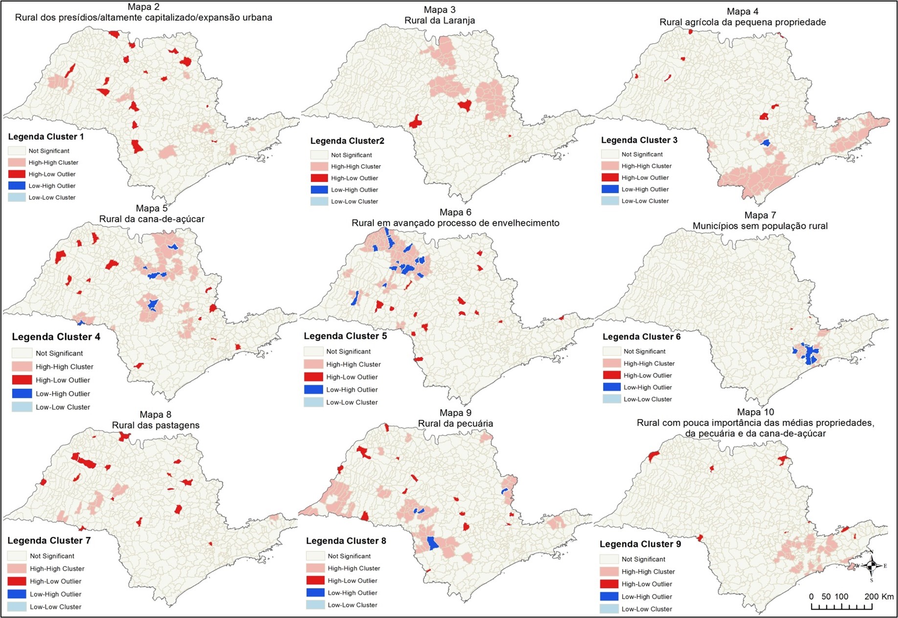
AbstractThe objective of this study is to analyze population distribution in the state of Pará in Brazil using data from the2010 Population Census in association with the land use and land cover data from TerraClass arranged in a statistical grid. The role of 113 Protected Areas (including 46 Indigenous Lands, 51 Sustainable Use Conservation Units and 16 Integral Protection Conservation Units) is analyzed from the standpoint of their demographic rural-urban gradients and in terms of their land use cover. Information on the use and cover of land in Protected Areas along with census data were incorporated into a statistical grid using GIS. The spatial relationship of information layers in the cells indicates that the state's population is highly concentrated in a few areas, a pattern that is reproduced to some extent in the Protected Areas (Gini coefficient for the distribution of households is higher than 0.9). The area of the Protected areas is less populated and retains a greater extension of forested areas, by comparison to the state. Despite having extensive segments devoid of occupied households and the largest expanse of forest coverage (57%) in the state, Protected Areas also have urban areas associated with other uses and land cover change. The results indicate that population dynamics and changes in the uses and covering of land are related in a broader manner, thereby suggesting the need for reflection on urbanization and changes in land use and land cover change within a more integrated approach.
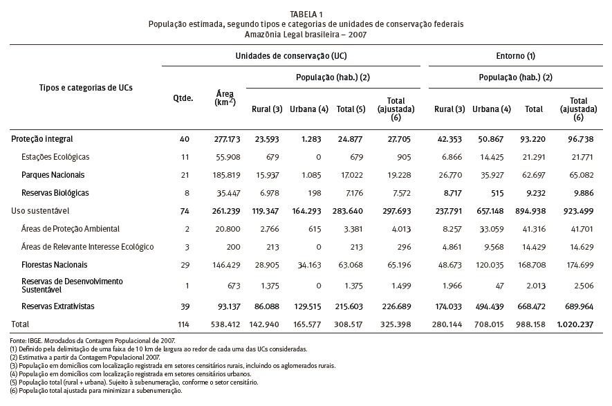
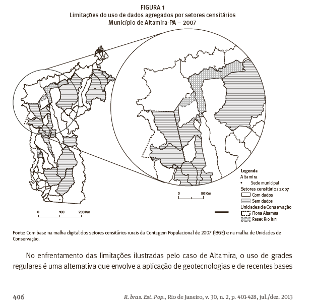
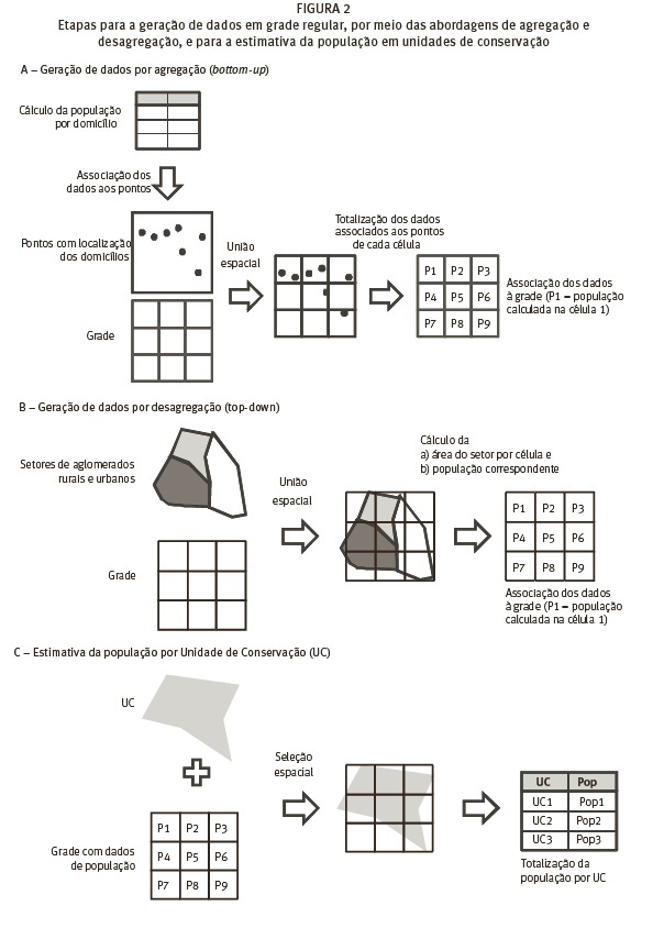
D’Antona Á, Bueno M, Dagnino R. Estimativa da população em unidades de conservação na Amazônia Legal brasileira – uma aplicação de grades regulares a partir da Contagem 2007. Revista Brasileira de Estudos de População. 2013;30(2):401-28.
AbstractIn this paper a method for increasing the resolution of census data is tested and presented, by aggregating the data onto a regular grid. The methodology consists of (1) the aggregation of households, represented by their geographical coordinates obtained by the 2007 Population Count, carried out by the Brazilian Census Office (IBGE) and, (2) the unbundling of the data by census tracts on the basis of proportionality. The grids obtained were used to estimate the resident population of 114 conservation units in Brazilian Legal Amazon, all of them instituted in or before 2006. The intention was to test this methodology on territorial units that follow neither the official political-administrative boundaries of states and cities, nor the boundaries designed by IBGE for collecting data. The methodology also contributes to the study of populations living in protected areas, due to the scarcity of population estimates in the conservation units. The results showed a population of 325,398 inhabitants in the selected units, 297,693 of whom were in units for Sustainable Use and 27,705 in Permanent Protection units. Adjoining areas have an estimated joint population of 1,020,237. Despite the limitations involved in using the 2007 Population Count, the aggregating of data into grids would seem to be a promising methodology in view of the improvements in IBGE's use of geotechnology. The grid minimizes problems that come up in the use of administrative units or census data and may represent an approach that can be applied usefully in demography and other areas of knowledge.

 Universidade Federal do Rio Grande do Sul - Campus Litoral Norte - Rodovia RS 030, nº. 11.700, Km 92 - Bairro Emboaba – CEP 95590-000 - Tramandaí, Rio Grande do Sul, Brasil - Telefone: +55 (51) 3308 1320 - 1340 - Website: https://www.ufrgs.br/litoral/