. Textos Nepo. 2015;72:60-80.
RESUMO
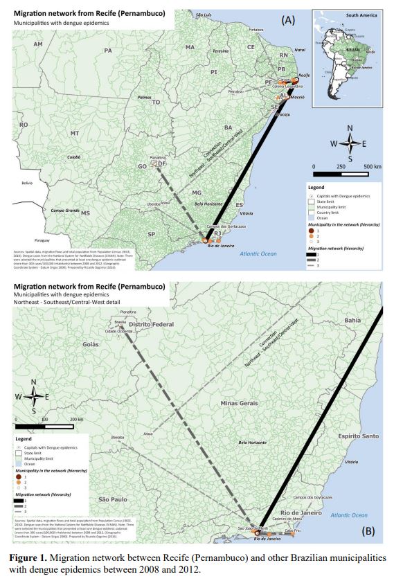
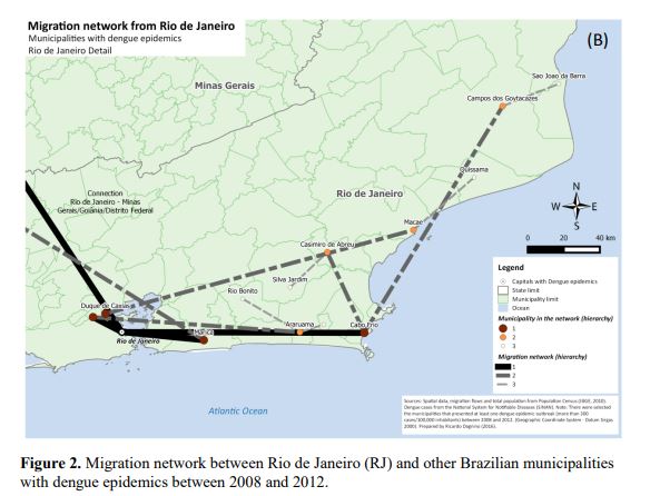
A febre chikungunya (CHIKV) pode ser entendida como uma doença semelhante à Dengue devido aos sintomas e à forma de transmissão. Pela rapidez que os casos autóctones estão se espalhando pelo Brasil, partindo de Oiapoque (Amapá) e Feira de Santana (Bahia), e a existência de numerosos casos de Dengue registrados em 2014 torna-se importante pensar de que forma e quais os caminhos/trajetórias que a CHIKV poderia se expandir pelo Brasil. O objetivo do trabalho é mapear as redes de cidades que estão ligadas aos dois primeiros municípios em que foram registrados casos autóctones de CHIKV no Brasil. Parte-se de dois pressupostos: de que essa rede pode estabelecer os liames da expansão espacial da doença no território e de que a mobilidade espacial da população é um aspecto fundamental para o estabelecimento das redes. Foi criado um modelo de rede de municípios, que se conectam por meio de movimentos migratórios e da mobilidade pendular para finalidades de trabalho ou estudo, com base no Censo Demográfico 2010. Considerou-se também no modelo a relação hierárquica entre os municípios, utilizando os resultados expressos na Região de Influência das Cidades (Regic). As análises espaciais indicam que a expansão da CHIKV poderia seguir dois caminhos, um partindo do Oiapoque e mais restrito à região Norte do Brasil e avançando em direção ao Oeste; e outro eixo mais amplo, partindo de Feira de Santana, com penetração da doença em direção ao Sudeste, inclusive com desdobramentos sobre as principais aglomerações urbanas do país: São Paulo e Rio de Janeiro.
Palavras-chave: Febre chikungunya. Trajetórias. Migração. Mobilidade Espacial da População. Brasil.
ABSTRACT
The chikungunya fever (CHIKV) is similar to Dengue fever in symptoms and transmission. The speed that the autochthonous cases are spreading throughout Brazil, from Oiapoque (Amapá) and Feira de Santana (Bahia), and the existence of numerous cases of dengue recorded in 2014 becomes important to think about how and what trajectories that CHIKV could expand by Brazil. The objective is to map the networks of cities that are linked to the first two municipalities where autochthonous cases were reported of CHIKV in Brazil. It was necessary to search the network of municipalities that bind to these two, both with regard to population movements of long duration (emigration), as the movements of short duration, such as commuting to work or study, based on 2010 Census. It was also used the database of the Region of Influence of Cities. Spatial analysis indicate that the expansion of CHIKV could follow two paths, one starting from the Oiapoque and more restricted to northern Brazil and advancing towards the west; and other wider axis, starting from Feira de Santana, with penetration of the disease toward the Southeast, including major urban centers: Sao Paulo and Rio de Janeiro.
Keywords: Chikungunya Fever. Trajectories. Population movements. Brazil.
 Universidade Federal do Rio Grande do Sul - Campus Litoral Norte - Rodovia RS 030, nº. 11.700, Km 92 - Bairro Emboaba – CEP 95590-000 - Tramandaí, Rio Grande do Sul, Brasil - Telefone: +55 (51) 3308 1320 - 1340 - Website: https://www.ufrgs.br/litoral/